The South Leinster Way -
Kildavin to Carrick-on-Suir
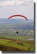
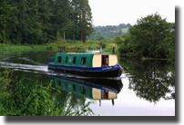
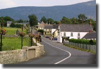
(The photographs on this
page are views from the South Leinster Way but may not
correspond to the stages where they are inserted.)
The South Leinster Way is a long distance
walking route which runs from Kildavin Co. Carlow to
Carrick-on-Suir in Co. Tipperary covering 102 km (64
miles) in length.
The predominant features in the landscape are Mount Leinster, Brandon
Hill and the river valleys of the Barrow, Nore and Suir. (The Three Sisters)
This stretch can be comfortably walked in five days but strong walkers
can finish it in three days.
Stage 1: Kildavin
- Borris
22km (14 miles)
From Kildavin the route passes along forest tracks over the northern
slopes of Mount Leinster to reach the town of Borris. The "Nine
Stones" vantage point at Mount Leinster offers amazing views of
the Barrow Valley and Brandon Hill. At 795 metres Mount Leinster is the
highest hill in the Blackstairs Mountains. The mast on top transmits
RTE television and radio to the entire region.
Stage 2: Borris
- Graiguenamanagh
12km (7 miles)
This stretch follows the towpath along the River Barrow and is particularly
attractive as it passes through rich deciduous woodland and old mills.
Clashganny Lock, 5km south of Borris is one of Carlow's and Ireland's
most famous landmarks. Graiguenamanagh marks the end of this stage -
a quayside, boating town lying in the county of Kilkenny but connected
via a fine bridge over the River Barrow to its twin village of Tinnahinch
in Co. Carlow.
Stage 3: Graiguenamanagh
- Inistioge
16km (10 miles)
This walk crosses the slopes of Mount Brandon by a series of forest walks
before reaching the pretty village of Inistioge. At 519 metres in height
Mount Brandon is the last significant hill of any size in the Leinster
granite chain and offers superb views of the surrounding countryside.
There is a view indicator, pointing out the principle attractions in
South East Ireland and a large cross. In recent years, Inistioge has
witnessed the development of the film making industry in Ireland. Famous
films shot here include Widow's Peak and Circle of Friends.
Stage
4: Inistioge - Mullinavat
30km (19 miles)
Suitable for the seasoned walker. This section of the way starts along
the banks of the River Nore and continues via forest roads over several
hills to reach Mullinavat.
Stage 5: Mullinavat
- Carrick-on-Suir
22km (14 miles)
This stretch crosses the River Blackwater and passes the village of Piltown
en route to the end of the walk in Carrick-on-Suir.